


GR70_Florac-St-GERMAIN

svp59
User
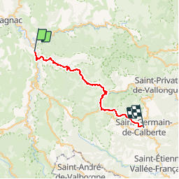

Length
34 km

Max alt
1032 m

Uphill gradient
905 m
Km-Effort
46 km

Min alt
496 m

Downhill gradient
954 m
Boucle
No
Creation date :
2014-12-10 00:00:00.0
Updated on :
2014-12-10 00:00:00.0
10h14
Difficulty : Medium

FREE GPS app for hiking
 SityTrail
IGN / Geographical institutes
SityTrail Plus
The world is yours!
About
Trail Walking of 34 km to be discovered at Occitania, Lozère, Florac Trois Rivières. This trail is proposed by svp59.
Positioning
Country:
France
Region :
Occitania
Department/Province :
Lozère
Municipality :
Florac Trois Rivières
Location:
Florac
Start:(Dec)
Start:(UTM)
547380 ; 4908237 (31T) N.
Comments